

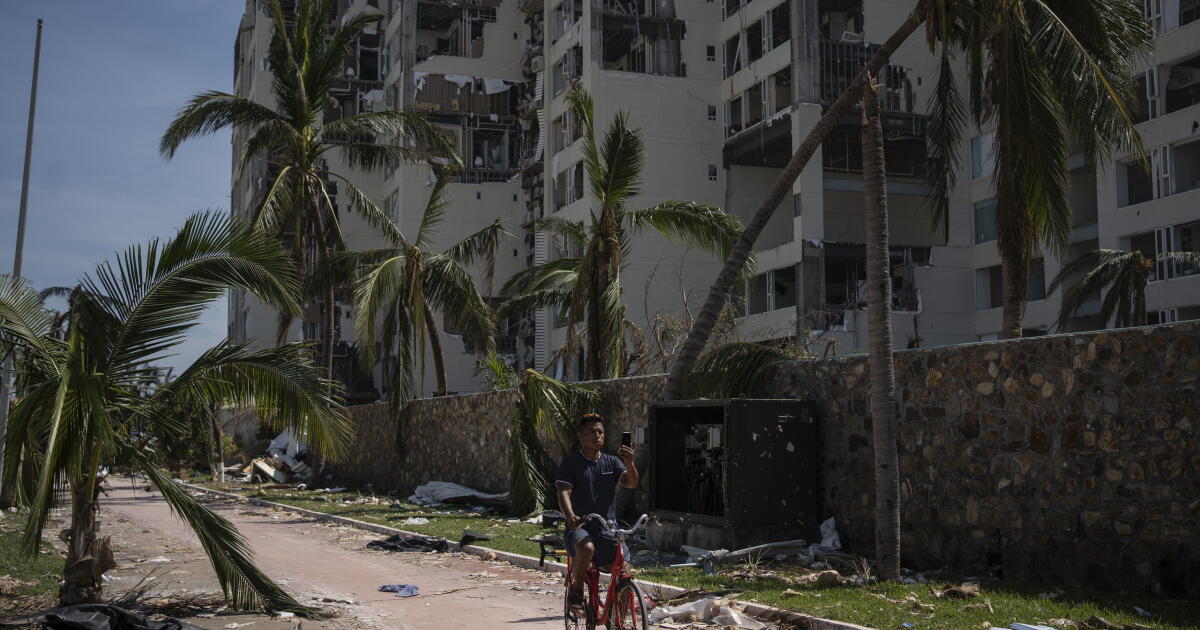
As officials continue to sort through the wreckage of last week’s devastating hurricane in Acapulco, new images show the scale of the disaster.
Hurricane Otis arrived in the early morning of Oct. 25, bringing rains and 165-mph winds, resulting in the most powerful storm ever recorded on Mexico’s Pacific coast.
By Tuesday morning, the official death toll was at 47, a figure expected to rise in the coming days.
The satellite images from Maxar Technologies show widespread damage to neighborhoods, hotels and marinas after the Category 5 storm.
The image below shows Acapulco Bay on Oct. 4 on the left.
On the right is the same area on Oct. 26, the day after the storm arrived. The image shows significant damage to buildings and flooding.
Scientists say Otis was the fastest-growing hurricane ever observed in the eastern Pacific Ocean. As oceans warm because of human-driven climate change, similarly super-charged hurricanes are likely to occur more frequently, they say.
In the days after the storm, a quarter-million homes were without electricity, and food, gasoline and clean water were in short supply. With little aid distribution and few if any shops open for business, many in the city of nearly 1 million resorted to pillaging shattered storefronts, according to reports by The Times.
The image below shows Acapulco’s La Poza neighborhood, which sits southeast of the bay and abuts a lagoon, on Oct. 4.
By Oct. 26, much of the neighborhood had been inundated with brown floodwaters. Homes and roads alike were underwater.
Disaster modeler Enki Research predicts that the economic impact may top $15 billion, and some locals worry that recovery of the coastal resort city, once favored by Hollywood stars but in recent years tarnished by drug violence, could drag on for years.
Many of the deaths in Acapulco appeared to be due to the sinking of 33 boats during the storm, the Mexican navy said Tuesday.
The image below shows several marinas filled with boats in Acapulco Bay on Oct. 4.
On Oct. 26, many of the marinas were visibly damaged and most of the boats were gone.
In previous hurricanes in Acapulco, most of the dead were swept away by flooding on land. But with Otis, a significant number appear to have died at sea. Residents have said that some crews had either chosen or been ordered to stay aboard to guard their craft.
Times staff writers Patrick J. McDonnell, Kathe Linthicum, Leila Miller and the Associated Press contributed to this report.

As officials continue to sort through the wreckage of last week’s devastating hurricane in Acapulco, new images show the scale of the disaster.
Hurricane Otis arrived in the early morning of Oct. 25, bringing rains and 165-mph winds, resulting in the most powerful storm ever recorded on Mexico’s Pacific coast.
By Tuesday morning, the official death toll was at 47, a figure expected to rise in the coming days.
The satellite images from Maxar Technologies show widespread damage to neighborhoods, hotels and marinas after the Category 5 storm.
The image below shows Acapulco Bay on Oct. 4 on the left.
On the right is the same area on Oct. 26, the day after the storm arrived. The image shows significant damage to buildings and flooding.
Scientists say Otis was the fastest-growing hurricane ever observed in the eastern Pacific Ocean. As oceans warm because of human-driven climate change, similarly super-charged hurricanes are likely to occur more frequently, they say.
In the days after the storm, a quarter-million homes were without electricity, and food, gasoline and clean water were in short supply. With little aid distribution and few if any shops open for business, many in the city of nearly 1 million resorted to pillaging shattered storefronts, according to reports by The Times.
The image below shows Acapulco’s La Poza neighborhood, which sits southeast of the bay and abuts a lagoon, on Oct. 4.
By Oct. 26, much of the neighborhood had been inundated with brown floodwaters. Homes and roads alike were underwater.
Disaster modeler Enki Research predicts that the economic impact may top $15 billion, and some locals worry that recovery of the coastal resort city, once favored by Hollywood stars but in recent years tarnished by drug violence, could drag on for years.
Many of the deaths in Acapulco appeared to be due to the sinking of 33 boats during the storm, the Mexican navy said Tuesday.
The image below shows several marinas filled with boats in Acapulco Bay on Oct. 4.
On Oct. 26, many of the marinas were visibly damaged and most of the boats were gone.
In previous hurricanes in Acapulco, most of the dead were swept away by flooding on land. But with Otis, a significant number appear to have died at sea. Residents have said that some crews had either chosen or been ordered to stay aboard to guard their craft.
Times staff writers Patrick J. McDonnell, Kathe Linthicum, Leila Miller and the Associated Press contributed to this report.

As officials continue to sort through the wreckage of last week’s devastating hurricane in Acapulco, new images show the scale of the disaster.
Hurricane Otis arrived in the early morning of Oct. 25, bringing rains and 165-mph winds, resulting in the most powerful storm ever recorded on Mexico’s Pacific coast.
By Tuesday morning, the official death toll was at 47, a figure expected to rise in the coming days.
The satellite images from Maxar Technologies show widespread damage to neighborhoods, hotels and marinas after the Category 5 storm.
The image below shows Acapulco Bay on Oct. 4 on the left.
On the right is the same area on Oct. 26, the day after the storm arrived. The image shows significant damage to buildings and flooding.
Scientists say Otis was the fastest-growing hurricane ever observed in the eastern Pacific Ocean. As oceans warm because of human-driven climate change, similarly super-charged hurricanes are likely to occur more frequently, they say.
In the days after the storm, a quarter-million homes were without electricity, and food, gasoline and clean water were in short supply. With little aid distribution and few if any shops open for business, many in the city of nearly 1 million resorted to pillaging shattered storefronts, according to reports by The Times.
The image below shows Acapulco’s La Poza neighborhood, which sits southeast of the bay and abuts a lagoon, on Oct. 4.
By Oct. 26, much of the neighborhood had been inundated with brown floodwaters. Homes and roads alike were underwater.
Disaster modeler Enki Research predicts that the economic impact may top $15 billion, and some locals worry that recovery of the coastal resort city, once favored by Hollywood stars but in recent years tarnished by drug violence, could drag on for years.
Many of the deaths in Acapulco appeared to be due to the sinking of 33 boats during the storm, the Mexican navy said Tuesday.
The image below shows several marinas filled with boats in Acapulco Bay on Oct. 4.
On Oct. 26, many of the marinas were visibly damaged and most of the boats were gone.
In previous hurricanes in Acapulco, most of the dead were swept away by flooding on land. But with Otis, a significant number appear to have died at sea. Residents have said that some crews had either chosen or been ordered to stay aboard to guard their craft.
Times staff writers Patrick J. McDonnell, Kathe Linthicum, Leila Miller and the Associated Press contributed to this report.

As officials continue to sort through the wreckage of last week’s devastating hurricane in Acapulco, new images show the scale of the disaster.
Hurricane Otis arrived in the early morning of Oct. 25, bringing rains and 165-mph winds, resulting in the most powerful storm ever recorded on Mexico’s Pacific coast.
By Tuesday morning, the official death toll was at 47, a figure expected to rise in the coming days.
The satellite images from Maxar Technologies show widespread damage to neighborhoods, hotels and marinas after the Category 5 storm.
The image below shows Acapulco Bay on Oct. 4 on the left.
On the right is the same area on Oct. 26, the day after the storm arrived. The image shows significant damage to buildings and flooding.
Scientists say Otis was the fastest-growing hurricane ever observed in the eastern Pacific Ocean. As oceans warm because of human-driven climate change, similarly super-charged hurricanes are likely to occur more frequently, they say.
In the days after the storm, a quarter-million homes were without electricity, and food, gasoline and clean water were in short supply. With little aid distribution and few if any shops open for business, many in the city of nearly 1 million resorted to pillaging shattered storefronts, according to reports by The Times.
The image below shows Acapulco’s La Poza neighborhood, which sits southeast of the bay and abuts a lagoon, on Oct. 4.
By Oct. 26, much of the neighborhood had been inundated with brown floodwaters. Homes and roads alike were underwater.
Disaster modeler Enki Research predicts that the economic impact may top $15 billion, and some locals worry that recovery of the coastal resort city, once favored by Hollywood stars but in recent years tarnished by drug violence, could drag on for years.
Many of the deaths in Acapulco appeared to be due to the sinking of 33 boats during the storm, the Mexican navy said Tuesday.
The image below shows several marinas filled with boats in Acapulco Bay on Oct. 4.
On Oct. 26, many of the marinas were visibly damaged and most of the boats were gone.
In previous hurricanes in Acapulco, most of the dead were swept away by flooding on land. But with Otis, a significant number appear to have died at sea. Residents have said that some crews had either chosen or been ordered to stay aboard to guard their craft.
Times staff writers Patrick J. McDonnell, Kathe Linthicum, Leila Miller and the Associated Press contributed to this report.

As officials continue to sort through the wreckage of last week’s devastating hurricane in Acapulco, new images show the scale of the disaster.
Hurricane Otis arrived in the early morning of Oct. 25, bringing rains and 165-mph winds, resulting in the most powerful storm ever recorded on Mexico’s Pacific coast.
By Tuesday morning, the official death toll was at 47, a figure expected to rise in the coming days.
The satellite images from Maxar Technologies show widespread damage to neighborhoods, hotels and marinas after the Category 5 storm.
The image below shows Acapulco Bay on Oct. 4 on the left.
On the right is the same area on Oct. 26, the day after the storm arrived. The image shows significant damage to buildings and flooding.
Scientists say Otis was the fastest-growing hurricane ever observed in the eastern Pacific Ocean. As oceans warm because of human-driven climate change, similarly super-charged hurricanes are likely to occur more frequently, they say.
In the days after the storm, a quarter-million homes were without electricity, and food, gasoline and clean water were in short supply. With little aid distribution and few if any shops open for business, many in the city of nearly 1 million resorted to pillaging shattered storefronts, according to reports by The Times.
The image below shows Acapulco’s La Poza neighborhood, which sits southeast of the bay and abuts a lagoon, on Oct. 4.
By Oct. 26, much of the neighborhood had been inundated with brown floodwaters. Homes and roads alike were underwater.
Disaster modeler Enki Research predicts that the economic impact may top $15 billion, and some locals worry that recovery of the coastal resort city, once favored by Hollywood stars but in recent years tarnished by drug violence, could drag on for years.
Many of the deaths in Acapulco appeared to be due to the sinking of 33 boats during the storm, the Mexican navy said Tuesday.
The image below shows several marinas filled with boats in Acapulco Bay on Oct. 4.
On Oct. 26, many of the marinas were visibly damaged and most of the boats were gone.
In previous hurricanes in Acapulco, most of the dead were swept away by flooding on land. But with Otis, a significant number appear to have died at sea. Residents have said that some crews had either chosen or been ordered to stay aboard to guard their craft.
Times staff writers Patrick J. McDonnell, Kathe Linthicum, Leila Miller and the Associated Press contributed to this report.